Haute Route - Sept 2007
Early morning flight to Geneva, followed by budget minibus connection, had us in sitting in the sun in a Chamonix cafe by saturday lunchtime! After a leisurely lunch we stocked up on a few things, such as camping gas cannister, and then headed off towards Argentière. The path wasn't overly unpleasant, quite quickly getting on to easy footpath through trees, and later on getting a bit hillier. At Argentière we got a room in the gite at the very bottom of the village, pleasant place and not too expensive, then nipped out to the supermarket to stock up on supplies for the next few days.
Argentière → Col de la Forclaz
- Lovely weather, blue skies and sunshine, although this meant that it was rather hot work on the climb up to the Col de Balme.
- We had already done this stage (via Trient) in reverse on the TMB. So we took the variant instead, which followed the TMB to the Col de Balme, then branched off towards the Refuge les Grands. It was nice walking, staying high up on a hillside traverse, with cracking views of the Glacier du Trient, and also tantalising views ahead to tomorrows stage over the Fenêtre d'Arpette
- After the Refuge les Grands, the path took an interesting slanting traverse across a cliff, on huge slabs that had been built up, presumably to allow donkey access to the refuge. Followed by long downhill past more cliffs to reach the river, and over to the Chalet du Glacier where we stopped for a very welcome cup of tea and a couple of packets of crisps
- From here the route headed down valley, but staying on a high traverse, on a level constructed path following a Bisse (artificial water course). Apparently this path used to have rails and was used to transport ice from the glacier to the hotel on the Col de la Forclaz!!
- Pitched up on the camping area next to the hotel, and cooked up pasta with a carton of vegetable soup that we got from the gift shop at the Col. We awarded the showers here the prize of 'Best showers of the trip' (even though we hadn't even seen the rest yet) - hot and very powerful, exactly what is needed after a day of walking!
Col de la Forclaz → Champex
- Totally clear skies made for a rather cold night. Blue skies and sunshine again in the morning, although quite a chilly start before the sun fully came up. We had missed out on the fenêtre during the TMB, so we were looking forward to it
- We reversed the ice-train path back to the Chalet du Glacier, looking forward to breakfast, but sadly it wasn't open yet, so we pushed on a bit further and made a start on the climb up to the fenetre before stopping for a snack
- About half way up we passed a small stone shelter that might serve as an emergency bivi. Outside it somebody had very thoughtfully taken a crap right in the middle of the path, together with a nice mound of toilet paper beside it.
- The path got more rocky and bouldery near the top, but not especially difficult, and we soon topped out, to find a crowd of people sitting in the sun on the other side. Pleasant enough spot, although a surprising amount of litter, people just seem to stuff their rubbish into the nearest gap between the rocks
- The descent starts off through a big boulder field, then down a lovely green valley, before arriving at the Relais d'Arpette for very welcome refreshments. After the relais, the final section to Champex takes a delightful path through forest following a stream at first, and then later on a bisse running alongside the path
- The last time we stayed in Champex it was chucking it down and we had to decamp to the gite, but no such problems this time and we pitched up in the campsite at the top of town then headed down for provisions. The supermarket was as poorly stocked as we remembered from last time, but we were able to get some very basic supplies, plus an extra gas cannister from the sports shop
Champex → Le Châble
- Some confusion leaving Champex, Kev told us to turn left on a gravel path, whilst unhelpfully omitting the fact that there was an earlier gravel path that you definitely shouldn't turn left on. Thankfully we quickly realised something wasn't quite right and some analysis of the map got us back on route without too much time lost
- More of a linking day really, no major passes or mountains, just an easy high traverse through grassy meadows along the Val d'Entremont to Sembrancher, and then along the river to Le Châble. Not overly unpleasant though, decent views down to the valley, and we even came across two small cultivated fields growing Edelweiss
- No camping at Le Châble, but there was a selection of hotels and B&B's to choose from. There was also a decent supermarket, and a tourist office, who made a Cabane du Mont Fort booking for us for the next day
Le Châble → Cabane du Mont Fort
- The restaurant at Clambin seemed completely closed up and deserted, so we pushed on to the picnic site at Le Hattey, where we stopped and had baguette and jam
- After leaving the forest, the path skirted round the hillside, following a bisse that was partly iced up, with excellent views of Grand Combin ahead of us
Cabane du Mont Fort → Refuge des Ecoulaies
- We got a decent start from the cabane. A few other teams were setting out at the same time, including a very fit looking team of guys from Yorkshire, an American chap, and an Australian couple. The first part traversed the hillside along the 'Sentier de Chamois', it was totally in the shade, and very cold. We had quite cold hands as we walked along this bit. Some of the streams had a layer of sheet ice hidden under the water, as I demonstrated by going flat on my arse in one of them, accompanied by a noisy clatter of walking poles, a splash, and some slightly flowery language. Aside from the cold and the ice, the traverse was very pleasant, slightly airy in places, and with increasingly impressive views of Grand Combin
- At Col Termin we popped out in the sun, and new views opened up of Lac de Louvie a long way below. Then there was another hillside traverse, a few slightly exposed sections but nothing too tricky, very pleasant in the sun, and getting increasingly rocky and bouldery as it got nearer to the Col Louvie.
- At Col Louvie, great views opened up of the large basin underneath the Grand Désert glacier, and grey rubble and boulders as far as the eye could see. The descent from the col down to the small lake at the bottom of the basin needed some care, clambering over assorted boulders, and steep scree. From the lake, a pile of stones led across the small outflow stream, and then the path started climbing following waymarks on occasional rocks. We stopped half way up beside a signpost and sat on a rock in the sun for a snack. A few more people arrived and also sat down nearby for something to eat. A Canadian chap turned up who had twisted his ankle on the descent from Col Louvie, he was hobbling a bit, but managing to continue at a reasonable pace, and was planning to push on to Cabane de Prafleuri where it looked like he would have to abandon the route. Very unlucky.
- From the snack stop it didn't seem like it should be that far to Col de Prafleuri, but the next section seemed to go on for ages. We continued climbing out of the large basin of glacial rubble, and reached a sort of plateau consisting of crumpled rock slabs, more boulders, and occasional patches of snow. At the end of the plateau there was a small cliff, and the path carefully picked its way across it, followed by a short bit of down climbing. Not technicaly difficult, but it required a bit of care, especially with some bits of snow on some of the ledges. After the cliff there was another section where the path meandered through more boulders and rocks. We could at least see the Col de Prafleuri by now, and after some very rocky clambering arrived at the top. The col overlooked a strange area of grey gravel and rock which had been shaped into various terraces and trackways, and we could just pick out the small Cabane de Prafleuri on the other side of it. At the Cabane itself we stopped for a snack in the sun, then pushed on over the small Col des Roux. Near the top we could see wild goats above us on the hillside
- We carried on as far as the Refuge des Ecoulaides. It was a nice place to stop, fairly small, and self catering, and we seemed to be the only people there. There were views down to the long lac le dix below, and Mont Blanc de Cheilon in the distance. We cooked up some pasta, and a few cups of tea, then adjourned to bed at about 8pm as it was getting quite dark and cold. We were lying in bed playing 'who am I?' when the door burst open and two German guys came in talking loudly. We could hear a larger group talking outside too. They tried various light switches, tried the door of the guardiens office, made a bit more noise and then promply left again. This got repeated a couple more times and then it went quiet again. We assumed they had been disappointed at the lack of electricity and had moved on to the next refuge which was 20 minutes away. After that it was quiet all night and we had a very pleasant nights sleep
Refuge des Ecoulaies → Arolla
- It was a lovely sunny morning again, and being up on the hillside the refuge got the sun quite early on. We had noodles for breakfast and some cups of tea, and then headed off. The path descended down to the lake and followed a track along the side of it. Most of the track was in the sun, but whenever it went into the shade the temperature dropped dramatically and there was patches of ice on some bits, and icicles hanging from nearby rocks. After a very icy area, it reached a lightweight suspension bridge which crossed a small gorge.
- The path climbed up the hillside in the sun. There were some edelweiss at the side of the path occasionally. On reaching a steep and rocky flood channel it climbed up the side of it on a steep path and then crossed it high up. After this the path gradually got rockier as it neared the Col de Reidmatten. There was a choice here of whether to take the col, or the Pas du Chèvres which consisted of a set of ladders going up a cliff. The path got a lot rougher as it approached the Pas, and involved stepping gingerly from boulder to boulder. Some of them looked stable but then rotated as you committed body weight to them, as I demonstrated by ending up sprawled over the boulders below, with accompanying clatter of poles, and some choice phrases. There were good views of the cliff and the ladders of the Pas du Chèvres as we got nearer, and at the fork we took this route, past a huge rock with a pointer painted in red on it, and a large picture of a ladder, just in case you didn't realise what you were heading for.
- The ladder section was quite interesting. Not technically difficult, and slightly off vertical so you could stand in balance, but the exposure added a bit of excitement. About two thirds of the way up the first ladder finished and it traversed right onto a ledge and joined another ladder, and I stopped and took some shots of the people coming up behind us. It was all in the shade, and the iron rungs felt very cold to the touch, so it was nice to pop out into the sun at the top, complete with row of prayer flags, and of course a brand new set of views.
- On the way down we pondered why it was called the Pas du Chèvres, you would be quite hard pressed to get a goat up it (or even down it) unless it was very agile indeed. A short distance down we came to the junction with the other route that had come over Col de Reidmatten. It was a lovely spot, so we sat in the sun for a while for a snack, in fact it was hard to drag ourselves away and get going again.
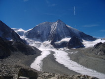
- Quite a long descent to Arolla, with increasingly superb views of the huge broken ice field of the Tsijiore Nouve glacier off to the side, and also of Mont Collon. Also great views of the long rocky ridge looming over Arolla on the other side of the valley, and the interesting shaped spike of the Aiguille de la Tsa sticking out the centre. Arolla seemed quite sleepy, the supermarket was closed despite it being during opening hours, and the tourist info place seemed to open for one hour each morning! But there were a good selection of hotels though. There was also a nice campsite down beside the river in the bottom of the valley. It was quite a drop down from the village centre, which was rather unwelcome last thing in the day, but it had nice grassy terraces catching (some of) the evening sun, decent showers, and a small shop with enough stuff to save us having to climb back up the hill!
Arolla → Les Haudères
- It was a bitterly cold night, and I ended up with most of my clothes on to supplement my lightweight two season sleeping bag. In the morning, everyone was scraping thick layers of ice from their cars. It took quite a while for the sun to reach the tent, but we refused to get going until it did. Instead we brewed up some tea, and I popped up to the campsite shop to get a fresh baguette which we had with apricot jam. We also washed some socks under the warm taps and hung them off my rucksac to dry.
- We had to climb back up to the village to get started, but it least it warmed us up a bit. The path climbed through trees, quite pleasant, before arriving at the tiny lake of Lac Bleu. It was quite a nice spot, and we sat down in the sun for a snack, and got the tent out to dry it off. After the empty path, the number of people at the lake seemed disproportionate to how good it actually was! We headed downhill to La Gouille, passing a lot of families on their way up. The route crossed the road, and continue on a wider track, past a small chapel next to a massive boulder, before arriving on the road just before Les Haudères.
- Les Haudères wasn't too bad a place, lots of hotels, old wooden barns stacked on big round stones on stilts (to stop rats climbing up), a couple of supermarkets, and a sports shop where I invested in a map for the rest of the route. As usual, the campsite was way down at the bottom of the village, but plenty of space, camped in a field surrounded by pink crocuses.
Les Haudères → Cabane de Moiry
- There was a lot of ascent today, so we didn't hang around too long, and got started by about quarter to eight. The tent was soaking wet so I strapped it to the side of my rucksac for drying later on. It was quite chilly walking back up through the quiet streets of Les Haudères. Kevs route went via La Sage, but that was just because there was a hotel and dortoir there, and we instead went via La Forclaz. Out of Les Haudères on the back streets, then up through the grassy meadows, the path went through wooden barns as it reached La Forclaz. There was a hotel there, which might be a backup if you had planned to go to La Sage and it was full.
- From Forclaz the route continued through meadows, passing various small clumps of barns and houses, to arrive at a couple of cow sheds at Remointe du Tsaté. We were out of the shade and back in the sun again now, and it was a nice day, mostly blue skies, with occasional clouds covering the sun for a short time. Here there were a few more people who where also heading over the Col du Tsaté. There was a choice of paths, and everyone headed off on the more obvious looking path which curved round the grassy hillside above the huts. We followed suit, but after a short while views of the tops appeared and something didn't seem quite right. A quick map inspection revealed that everyone was heading up towards Pte du Tsaté, not the col. After some studying of the map, we followed a stream for a short distance, and then did a bit of traversing across the hillside, which brought us back on to the proper path, and the reassuring waymark stripes. The proper path crossed over a rocky area, with tall rocky cliffs and scree above us on the right. We arrived at the col, and stopped for bread and jam.
- As we descended, we could see the strange coloured small glacial lake, half blue, half grey, and a huge car park (Parking du Glacier). Views appeared of a huge grey ridge of morraine skirting the valley above the car park. There was some disappointment to find that the promised buvette at the car park was all closed up, which seemed odd given how busy it was. There were lots of people milling around and kids playing. We sat down and had some more bread and jam.
- We pushed on towards the Cabane de Moiry. It seemed like a bit of a side-trip really, in that you had to walk up to the cabane, and then reverse the same path the next day to get back on route. But Kev reckoned that it was the finest setting of all the lodges on the haute route, so we hoped it would be worth it. The path was a bit busy at first, but very interesting walking, it climbed up to the top of a long ridge of glacial morraine and then followed the crest of it for a while. And looking down you could see the large ice flow of the glacier below, and a huge crumpled wall of ice ahead. Looking ahead you could see the cabane perched high up on a shoulder, and an almost infeasibly steep looking path zig-zagging its way up the hillside. It wasn't quite as steep as it looked, but still a bit of a pull to make it up to the cabane. We sat down on the picnic benches outside, and laid the tent out to dry in the afternoon sun. It was an incredible position, the huge steep broken icefield was right in your face, and you could look down to the smoother flow of the glacier below, and even pick out tiny figures walking across it.
- There were a few day trippers at the refuge, but they gradually disappeared as the afternoon wore on. The team of guys from Yorkshire were there, they had stayed at the dortoir at La Sage the previous night, and they looked quite tired, some were laid out on benches. Apparently a bunch of people had turned at the dortoir at 1am and insisted on partying until 5am, so nobody had got much sleep. The dormitories were an interesting demonstration of how tightly you could pack a large number of bunks into a very small room. But they were comfortable enough. Two guys from Keswick appeared and got two of the other bunks. Nice evening meal, only one snag, apart from a little bit for cooking, there was no running water anywhere, apparently the supply was frozen! So no washing, and the toilets were a bit unsavoury, and everyone had to drink either beer or fanta. A small price to pay for the absolutely superb situation of the refuge though.
Cabane de Moiry → Zinal
- Thankfully there was tea at breakfast time, despite the water shortage. Everybody got going at about the same time, and we all zig-zagged down the steep path, still quite chilly in the shade before the sun arrived in the valley. Great views again down to the main flow of the glacier below, it had a sort of gloomy blue tinge in the early morning light. The path went down to the big ridge of terminal morraine and reversed back along it, then picked up a traverse along the hillside, with the large man made Lac de Moiry down below. This eventually connected with the grassy path going up towards the Col de Sorebois, where we came of the shade into the sun, and the temperature immediately went up a few degrees. We sat down and had the last of our bread, with apricot jam
- After the snack we continued on towards the col. At first it was an easy angled grassy path, zig-zagging its way up, but it got rockier and steeper later on. We arrived at the col about midday. The hillside on the other side of the col was covered with ski lifts and jeep tracks, although there were great views opened up of Weisshorn in the distance. Steep descent to Sorebois, where we were disappointed to find that the cafe was closed on Mondays and Tuesdays. We got the stove out and made a pan of tea. There was more grassy track, then some pleasant singletrack through the trees down to Zinal.
- It was a reasonable size town, a selection of hotels, tourist info place, and decent sized supermarket. The tourist info people made a booking for us at the hotel at Gruben, then we stocked up at the super. As usual the campsite was at the far end of town.
Zinal → Gruben
- It was a clear and cold night again, so we emptied our rucksacs and used them to extend our 3/4 length thermarests so that out feet didn't get cold from the ground. The rucksac contents were in doubled up plastic bin bags anyway to keep them dry and we left the bin bags and their contents in the porch of the tent, inbetween the inner and the outer. During the night I heard a rustling. I looked out the tent inner into the porch and was shocked to find that both our bags had gone! I quickly unzipped the outer and peered out. I was just in time to see the back end of a fox disappearing down the hill. Our bags were a few metres from the tent, so I quickly nipped out and retrieved them. Impressive that the fox had managed to pull two fairly full bin bags underneath the outer of the tent, and they both had teeth marks in them.
- There were no more incidents during the night, and we got up and got going about 8am. It was very chilly, we had all of our clother on, and felt like we were operating on autopilot a bit, although we did manage to get a baguette from the boulangerie as we passed by. The path climbed through the trees, still in the shade and quite cold. There were quite a few other people on the move, including a big group of Americans. Eventually the path popped out at a grassy knoll, which was in the sun, and we stopped for a snack. Good views appeared, looking back to Zinal. The path traversed through bilberry bushes and other shrubs with a lovely autumn red tinge, some rocky bits, still in the sun, before turning a corner and going back into the shade for a while. We arrived at Alpe Nava, which was just a lone hut, and sat on a big rock and had baguette and jam.
- We pushed on, past a large cattle shed, and over a nice crumpled plateau. There were excellent views back to Zinal and surrounding snowy peaks, and looking forward to Bernese alps. After the plateau there were steeper zig-zags up to Col Forcletta. Excellent new views opened up. We sat on the col for a while and had a big packet of crisps and some apples. The path descended thru shiny schist, the first bit of the path was made of powdered schist that shimmered in the sun. We got to a grassier stretch, the stream flowed through a carpet of moss, excellent views of peaks that improved as we descended. There was a small hamlet at Chalte Berg and a big concrete cattle shed. The path got a bit vague for a while, passing lots of sheep. The last stretch traversed thru some big rocks, surrounded by bushes in red tinted autumn colours, then an easy path descending through a forest with nice pine aromas.
- A last short bit along the valley through meadows, lots of electric fences, then the small cluster of timber houses and the single large hotel at Gruben. We stocked up on some packets of crisps and a loaf of bread for the next day from the tiny shop next door before it closed. Nice hotel, clean and tidy, the dortoir area was on the top floor, big rooms with a lot of mattresses side by side spread across the floor. Our room had 14 mattresses, but there was only us and the two guys from Keswick, and two people who mysteriously arrived much later on, so there was plenty of space to spread out.
Gruben → St Niklaus
- We got going about 8 am, the valley was totally in shade, and quite chilly, there was a layer of frost on the grass. The path climbed up zig-zags through forest, then out onto open hillside. The hillside looked strangely reminiscent of the lake district, grassy slopes, with grey rocks scattered about, even the lichen on the rocks looked similar. One consequence of there only being one place to stay in Gruben, was that everybody was in the same place, and got going at almost the same time. So there was a string of people ahead and behind us. In general the ascent didn't require too much effort, although it did get a bit steeper near to the col, Augstbordpass.
- It was lovely and sunny at the col. The tent was still wet from Zinal, so I spread it out over the cairn to dry it out. We sat for a while and had bread and jam. The start of the descent was quite rocky, on a dusty path through scree, through a small canyon, then traversing across boulder fields. There were some sections across quite big boulders, some of them quite wobbly, so it needed a bit of care. Occasionally the colour of the rock would change dramatically as we went from one boulder field to the next. The path turned a corner and took a very pleasant traverse across a steep hillside before popping out at the shoulder at Twära where superb views opened up of the Dom and the Ried glacier below it. It was a lovely place to sit, and we hung around for a while sitting in the sun having a few snacks and taking photos before we got going again.
- The path descended, sometimes on big slabs, and then on a large constructed descending traverse towards Jungu. We almost made a wrong turn to Jungtal, but quickly spotted the mistake. The path went through the small hamlet at Jungu, winding its way through the old timber houses clustered together, then a final long descent on hairpins to St Niklaus, passing a whole series of small white shrines. We got a room in a small guesthouse very near the village square, and then adjourned to what seemed to be the one and only restaurant in the whole village.
St Niklaus → Zermatt
- Easy day, just a short walk up the valley to Zermatt. It started off on the road for quite a while, but eventually joined some forest tracks, passing more barns perched on stilts and big round stones.
- At Tasch campsite we bumped into Pete who was in the alps for a few weeks doing some mountaineering. He made us a cup of tea as we sat and drooled over all his camping equipment, full length extra thick thermarest, camping chairs, super efficient jetboil stove.